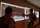
![Military personnel analyze satellite imagery and real-time data, showcasing advanced capabilities in military surveillance and strategic decision-making. [US Air Force]](/ssc/images/2026/02/13/54462-_65__surveillance_screens-600_384.webp)
The Tactical Surveillance, Reconnaissance and Tracking (TacSRT) program represents a cutting-edge initiative spearheaded by the US Space Force.
The program is designed to acquire unclassified commercial satellite imagery, advanced sensors and data analytics for military and strategic applications.
Capitalizing on the speed and innovation of commercial vendors, TacSRT enables real-time space-based surveillance solutions to enhance military decision-making and support combatant commanders.
Leveraging the Global Data Marketplace (GDM), online platform linking commercial providers with military needs, TacSRT provides rapid tasking, data delivery and funding of surveillance contracts.
Since its inception in 2023, the program has demonstrated immense potential, shaping operations from battlefield intelligence to disaster relief.
Supporting military missions with speed and precision
First introduced as a pilot effort, TacSRT has rapidly become a cornerstone of military operations.
Its defining success came during the 2024 US withdrawal from Niger, where the program closely tracked local terrain, vehicles and personnel to ensure troop safety.
The time from data collection to delivery on-site dropped to as little as 1.5 hours, showcasing TacSRT's pivotal role in safeguarding joint forces.
By the first quarter of 2025, TacSRT had produced 525 operational planning products (OPPs), with over 50 utilized during the Niger exit.
In a notable collaboration with US Southern Command, TacSRT provided real-time wildfire tracking in South America, aiding crisis response efforts across the region.
During Hurricane Helene relief in 2024, TacSRT provided imagery of road closures and bridge conditions, supporting emergency responders in Tennessee and North Carolina effectively.
These examples reflect its ability to seamlessly integrate commercial geospatial intelligence into both combat operations and humanitarian efforts.
Expanding capabilities through congressional support
Buoyed by early successes, the Space Force has scaled the TacSRT program to serve more combatant commands.
Its marketplace, which enables commanders to directly purchase commercial space imagery and analytics, has gained traction globally.
US Central Command employed TacSRT's services during the construction of key military infrastructure in Gaza, demonstrating the program's multi-theater applicability.
Recent congressional support further bolsters TacSRT's trajectory and signals growing confidence in the initiative.
Lawmakers earmarked a $40 million funding increase in 2025 urging the Space Force to expand surveillance capabilities into very-low-Earth orbit.
The service's "surveillance-as-a-service" approach has garnered praise for its swiftness compared to traditional intelligence systems, paving the way for widespread adoption across combatant commands.
With its robust portfolio of battlefield mapping, route planning and geospatial intelligence, TacSRT is redefining modern warfare.
By integrating space-based commercial resources, the Space Force is not only maximizing efficiency but also ensuring military readiness in an increasingly dynamic landscape.
As the program evolves, it promises to remain a vital tool in both crisis response and tactical operations worldwide.