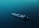
![A REMUS 600 unmanned undersea vehicle is lowered into the water during mine search and identification exercise operations. Demonstrating the US Navy's ability to detect and classify underwater threats while reducing risk to sailors and manned platforms. [US Navy]](/ssc/images/2026/05/21/56168-_138__remus_600-600_384.webp)
The United States is expanding unmanned undersea operations to strengthen maritime awareness across the vast CENTCOM theater.
These deployments highlight Washington's role as the preferred security partner for allies seeking advanced, proven defense technologies.
The center of this effort is the Remote Environmental Monitoring Units (REMUS) 600 unmanned undersea vehicle (UUV), a modular autonomous system designed for demanding naval missions.
The REMUS family is designed to conduct efficient seabed mapping, underwater reconnaissance and oceanographic data collection in demanding maritime environments.
The REMUS 600 can operate for nearly 70 hours, travel up to 286 nautical miles and dive to depths of 600 meters.
Its modular architecture allows operators to quickly swap payloads for mine countermeasures (MCM), hydrographic surveys and underwater reconnaissance missions.
Mapping the hidden battlespace
In CENTCOM, these vehicles support intelligence preparation of the operational environment (IPOE) in contested littoral waters.
The systems can enter anti-access/area denial (A2/AD) environments without exposing submarines or surface ships to unnecessary risk.
Using side-scan sonar and other sensors, they create detailed seabed maps and detect potential hazards.
Specialized littoral battlespace sensing (LBS-AUV) variants also gather conductivity, temperature and depth information throughout the water column.
This oceanographic data refines acoustic models used by anti-submarine warfare (ASW) forces to improve sonar performance.
Over a typical 72-hour period, operators can survey chokepoints, approaches and other strategically significant maritime terrain.
The vehicles follow preprogrammed routes semi-autonomously before returning to recovery points for rapid data download and analysis.
Trusted technology, shared security
These operations provide commanders with precise environmental intelligence before naval forces enter uncertain waters.
Regional partners benefit from systems that are combat-tested, reliable and supported by decades of American undersea expertise.
The US offers allies more than equipment by delivering training, interoperability and enduring strategic cooperation.
That combination strengthens deterrence while helping partners monitor critical sea lanes and protect sovereign interests.
As undersea competition intensifies, unmanned systems like the REMUS 600 are expanding awareness where silence often determines advantage.


Good
ReplyThanks for this info
Reply